Lake Wedowee Life magazine
  • HOME
    • About US
  • LAKE WEDOWEE GUIDE
    • BUSINESS DIRECTORY
    • SPONSORS
  • 2025 Issues
    • 2024 ISSUES
    • 2023 iSSUES
    • BACK ISSUES
  • Blog
  • LWL Advertising
    • WEDOtv Billboards
Picture
Discover more about Lake Wedowee and the surrounding area through
​the Wedowee Lake Life blog.
  

Lake Wedowee Map

7/7/2018

2 Comments


The Lake Wedowee Map - Your Guide To Public Boat Ramps

Lake Wedowee Map
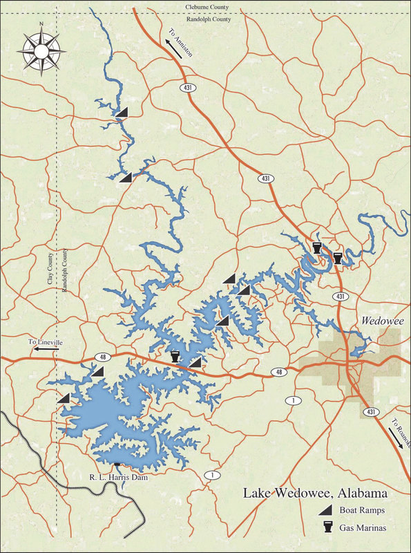
Lake Wedowee Map
The Lake Wedowee map is marked with the location of  the public boat ramps and places to get gas on the water.  Below is the road reference to each ramp. 
  • Lee's Bridge Public Boat Ramp off County Rd 88
  • Foster's Bridge Public Boat Ramp off County Rd 82
  • Swagg Public Boat Ramp off County Rd 329
  • Lonnie Whites Public Boat Ramp off County Rd 129
  • Crescent Creek Public Boat Ramp off County Rd 240
  • Highway 48 Bridge Public Boat Ramp off Hwy 48 (at bridge)
  • Fox Creek Public Boat Ramp off County Rd 863
  • Little Fox Creek Public Boat Ramp off New Harmony Church Rd
#ilovelakewedowee #LakeWedoweeBoatRamps #homeonthelake
2 Comments
Al link
6/21/2020 02:04:51 pm

Crappie

Reply
Fencing Contractors Pawtucket link
5/12/2024 09:27:49 pm

Thanks for taking the time to share this

Reply


Leave a Reply.

    Lake Life Categories

    All
    Boating
    Community
    Home On The Lake
    Nature Around Us
    On The Cover
    On The Water
    Throwback Thursday


    RSS Feed

Vertical Divider
All content in this publication is protected by United States copyright law and may not be reproduced, distributed, transmitted, displayed, or otherwise published without the prior written permission from Wedowee Media, Inc.


©2008-2025 WEDO Media, Inc. 

Photo from Fort George G. Meade
  • HOME
    • About US
  • LAKE WEDOWEE GUIDE
    • BUSINESS DIRECTORY
    • SPONSORS
  • 2025 Issues
    • 2024 ISSUES
    • 2023 iSSUES
    • BACK ISSUES
  • Blog
  • LWL Advertising
    • WEDOtv Billboards